The area of Málaga Province occupying the south of Spain (Andalucía) is an excellent riding destiny with perfect weather, long ascents & descents on perfect asphalt and important gastronomical background.
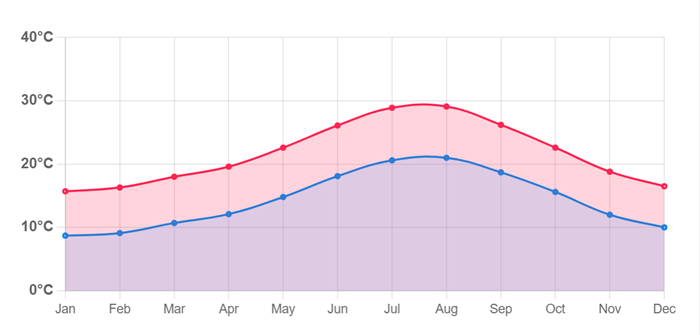
The most appreciated is the winter weather with daily temperature around 15 degrees, mostly sunny, so riding and pre-season training is highly efficient until April.
Index
- Málaga – Puerto del León – Olías – Málaga (46 KM)
- Málaga – Torre del Mar – Zafarraya – Alfarnate – Colmenar – Málaga (135 KM)
- Málaga – Álora – Valle del Abdalajís – GUADALHORCE DAMN- El Chorro – Álora – Málaga (110 KM)
- Málaga – Almogía – Villanueva de la Concepción – EL TORCAL – Siete Revueltas – Málaga (100 KM)
- Málaga – Almayate – Benamocarra – Iznate – Málaga (75 KM)
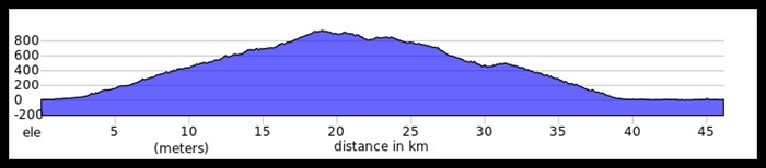
1. Málaga – Puerto del León – Olías – Málaga
Distance: 46 KM
Elevation Gained: 1.100 M
Pit Stops: Venta Carlos, Venta El Boticario, Fuente de la Reina, Venta León, Venta Galway.
This HOME LOOP for all locals is basically one climb from city center to a pass Puerto del León at any 900 m.a.s.
Stunning views over Bay of Málaga, city and sometimes over Africa.
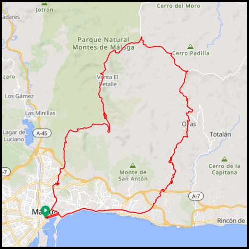
Starting next to the street Larios, just go through tunnel or along the Roman Theater to reach Street Calle Victoria and later road Camino Colmenar which leads up to desired pass Puerto de León. Next to restaurant Venta Galway turn right to follow village Olías.
Exceptional descent with lovely views over Mediterranean is secured. While descending to the shoreline, along the promenade one stop is a MUST.
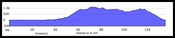
2. Málaga – Torre del Mar – Zafarraya – Alfarnate – Colmenar – Málaga
Distance: 135 KM
Elevation Gained: 2.100 M
Pit Stops: Torre del Mar, Ventas de Zafarraya, Venta de Alfarnate, Colmenar, Venta Galway, Fuente de la Reina.
A ride heading east, firstly along the coast to turn inland later to hit passes like Boquette de Zafarraya, Cerro del Moro or Alazores between impressive range of mountains.
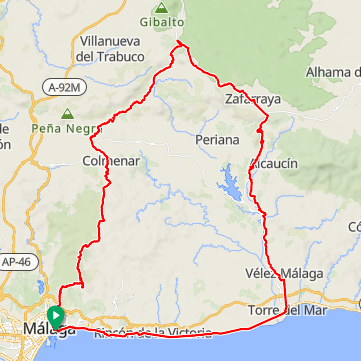
Starting in front of Málaga town-hall the route goes east along the shoreline for any 30 KM to Torre del Mar. Since that point, heading to the north comes hills. The first real climb is Boquette de Zafarraya, any 12 KM to 900 m.a.s. where borders Granada Province. Passing the village Zafarraya comes ascent to the highest summit Cerro del Moro at any 1.113 m.a.s. Comes fast descent to crossroad and another climb to pass Los Alazores (1.040 m.a.s.).
Since that point the track is undulated until you reach Colmenar, where comes road to pass Puerto del León (900 m.a.s.) along the N.P. Málaga Mountains. Once in pass, there are some refreshment points and long 16 KM fast descent to the city.
3. Málaga – Álora – Valle del Abdalajís – DAMN – El Chorro – Álora – Málaga
Distance: 136 KM
Elevation Gained: 1.700 M
Pit Stops: Pizarra, Álora, El Kiosko (crown of damns), El Chorro.
A ride to the north to discover impressive system of damns above Málaga topped by superb views over famous gorge Caminito del Rey in El Chorro.
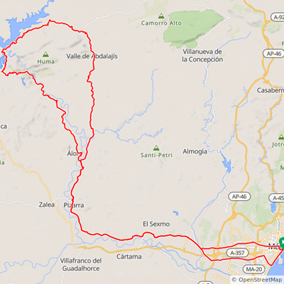
Starting in Alameda Principal street it takes time to leave city, but through streets Mármoles, Carlos Haya and Maldonado, the track will bring you out of Málaga. Keep on road to Pizarra and before Álora take turn right to Valle del Abdalajís. At that moment comes initial climbs. Shortly after Valle del Abdalajís, take sharp turn left direction Estación Gobantes train station – real climbs and empty landscape will keep you company.
Ridden 10 KM pay attention on the next crossroad, do not follow station anymore and turn left to ride along the first damn. Undulated road behing the range of mountains brings you to crowns of all 3 damns (Guadalhorce, Guadalteba and Conde de Guadalhorce). There is few amazing bars and restaurants.
Last section is climb along the last reservoir and lovely descent between pines to El Chorro with its walkway in narrow gorge called Caminito del Rey and hydro-power plant reservoir. Both impressive. There is the journey back left, any 50 KM, mostly descending to Málaga.
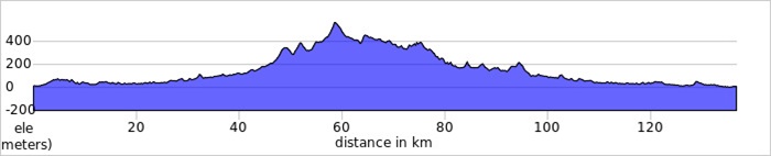
4. Málaga – Almogía – Villanueva de la Concepción – EL TORCAL (N.R.)- Málaga
Distance: 100 KM
Elevation Gained: 2.000 M
Pit Stops: Almogía, Villanueva de la Concepción, El Torcal.
Lovely ride to discover beauty of Nature Reserve El Torcal, a karstic rock formation uplifted from sea bed during Tertiary Period.
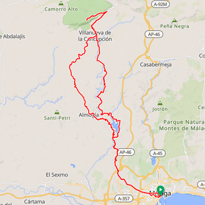
Starting in Alameda Principal street ride to the river and turn left through streets Mármoles, Carlos Haya and Lope de Vega to leave Málaga. Once you are out of the city follow signs for Almogía (road MA-3402) climbing along the reservoir Casasola. Passing the village road become MA-3402 till Villanueva de la Concepción, small town just under the majestic rock massif El Torcal.
The last section has two parts, first section is climb from town to crossroad under El Torcal and then proper climb to Visitor´s Center of El Torcal, both demanding ascent with excellent views.
Having enjoyed the altitude of any 1.200 m.a.s. and stunning views over surrounding mountains, tide back over the same road till Villanueva de la Concepción and turn left to descent over A-7075 through valley of river Campanillas back to Málaga.
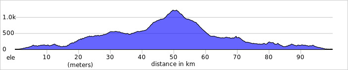
5. Málaga – Almayate – Benamocarra – Iznate – Málaga
Distance: 75 KM
Elevation Gained: 700 M
Pit Stops: Every single KM.
Short COFFEE RIDE along the coast called BACALAO (Cod) by locals has one mild hill close to coast, the way back along the shoreline again.
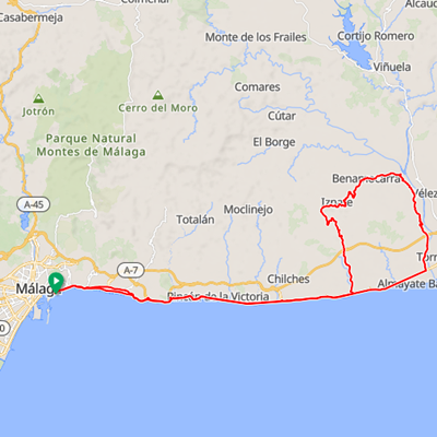
Starting in promenade you are on N-340 for next 30 KM, so ride next to shoreline through towns of La Cala del Moral, Rincón de la Victoria until Almayate. Shortly before the bridge over river Río de Vélez turn left to take small back-road and avoid rush of Torre del Mar. Undulated road brings you back to main road before town Benamocarra with bar next to the road.
The gentle climb is ahead (road MA-3118/3115). Ride between avocado plantations along the Iznate to reach highest point, a small summit called Alto de Iznate. Since that point only 10 KM long descent and flat ride back along the shoreline are left. So enjoy and get a refreshment as there is plenty of nice spots.

