The area of Granada Province (Andalucía) is famous for its hilly profile dominated by huge & beautiful range of mountains called Sierra Nevada with the highest peak of continental Spain – Mulhacén (3.482 m.a.s.)
So riding around these hills means: long ascent, long descents and exceptional elevation gained during every single ride.
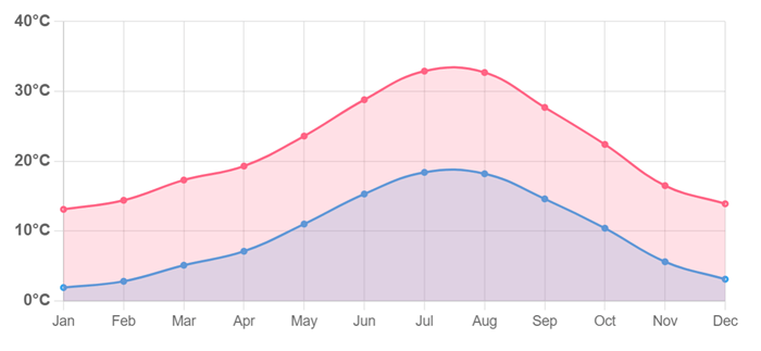
The winter and spring can be chilly (10 degrees) with occasional snow on upper slopes over 1.000 M. During the summer and autumn the fresh mornings and hot evenings are excellent to ride up to 3.396 m.a.s. of mighty Veleta Peak.
Index
- Órgiva – Pampaneira – Trevélez – Almegíjar – Órgiva (76 KM)
- Órgiva – Haza del Lino – Cádiar – Torvizcón – Órgiva (80 KM)
- (SEA & MOUNTAINS) Órgiva – Rubite – Castell de Ferro – Motril – Vélez Benaudalla – Órgiva (95 KM)
- (EUROPEAN HIGHEST ROAD) Granada – Monachil – Pradollano – VELETA PEAK -Pradollano – Cenes de la Vega – Granada (98 KM)
- (AROUND SIERRA NEVADA) Granada – Guadix – LA RAGUA pass – Laroles – Trevélez – Órgiva – Granada (249 KM)
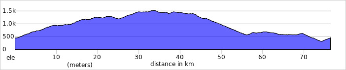
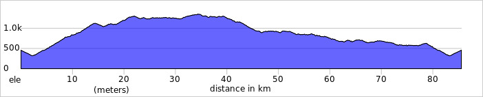
1. Órgiva – Pampaneira – Trevélez – Almegíjar – Órgiva
Distance: 76 KM
Elevation Gained: 1.800 M
Pit Stops: Pampaneira, Pitres, Pórtugos, Busquístar, Trevélez.
Shorter loop from capital of Las Alpujarras heading to the southern slopes of Sierra Nevada to famous villages like Pampaneira or Serrano Ham Village Trevélez.
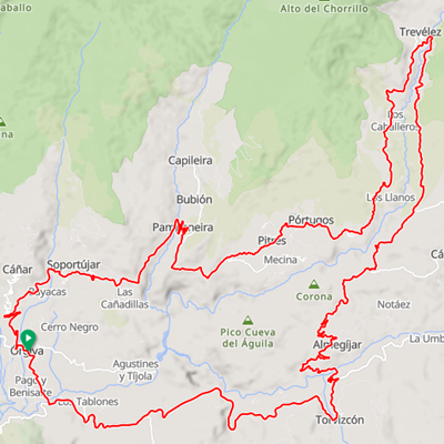
Starting in the center of Órgiva, take direction to Lanjarón, on the 1st roundabout turn right up to Pampaneira. Beautiful long ascent of 15 KM with nice views over valley and mountains around. It´s getting steep while riding through Pampaneira, but there are lots of refreshment points.
Next section is undulated terrain over Pitres to Busquístar where starts 10 KM long climb to Trevélez – the highest village in Spain (1.500 m.a.s.) famous for its excellent production of Serrano Ham.
Since Trevélez comes again impressive undulated road to crossroad and pass Portichuelo de Cástaras (1.398 m.a.s.), turn right to Almegíjar village. 13 KM long technical descent to valley of river Río Guadalfeo brings many beautiful photo spots. Since river valley climb to main road A-348 and over Torvizcón ride back to Órgiva.
2. Órgiva – Haza del Lino – Cádiar – Torvizcón – Órgiva
Distance: 85 KM
Elevation Gained: 1.900 M
Pit Stops: Haza del Lino, Cádiar, Torvizcón.
Nice ride around the mountains Sierra de la Contraviesa, a southern range of mountains with spectacular views over shoreline and even more impressive views over Sierra Nevada massif located in the north.
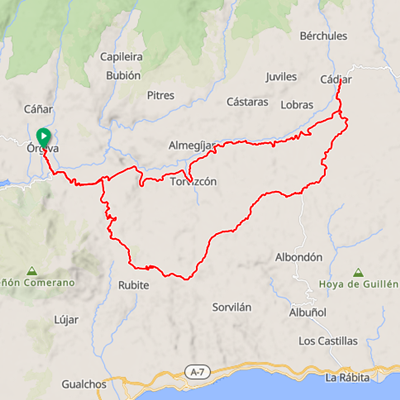
Starting in the center of Órgiva descent down to valley of the river, crossing the bridge turn left direction Cádiar. Having ridden any 6 KM turn right to climb up to pass Puerto Camacho (1.125 m.a.s.). The road ease up for a while, then comes other climb to pass Haza del Lino (1.301 m.a.s.).
Descend to the crossroad with restaurant Haza del Lino and turn left, direction Cádiar over GR-5204. Undulated road for any 15 KM offers plenty of beautiful viewpoints over both sides. When you reach crossroad with A-345 take left, again to Cádiar. Short flat section is soon changed by fast descent to the valley, still on A-345. On the crossroad keep on to town to get refreshment.
Last part is descent through the valley of the river Guadalfeo with occasional short punchy slopes. Torvizcón is the last point to get some snack before you reach Órgiva.
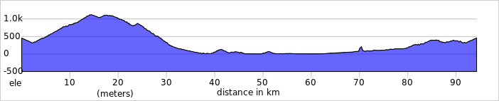
3. (SEA & MOUNTAINS) Órgiva – Rubite – Castell de Ferro – Motril – Vélez Benaudalla – Órgiva
Distance: 95 KM
Elevation Gained: 2.000 M
Pit Stops: Rubite, Castell de Ferro, Calahonda, Motril, Vélez Benaudalla.
A dreamy loop for everybody, climbing the real hill, descent to the shoreline to enjoy excellent seafood and back to the mountains.
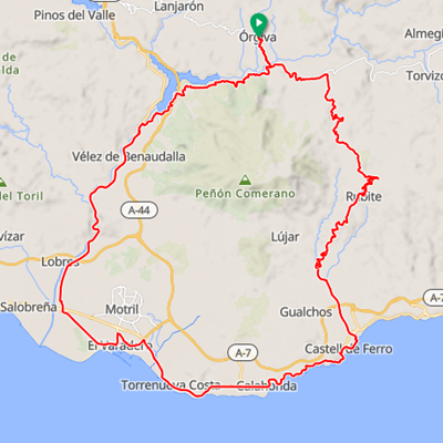
Starting in Órgiva, descent to the river. Crossing the bridge turn left direction Cádiar and in any 6 KM right to start the climb of the day over A-4131 to the pass Puerto Camacho (1.125 m.a.s.). Lovely climb between impressive rocky walls brings you up and road flattened bit before last slope before the crossroad. Turn right to Rubite village and stay on road GR-5206 till the beach in the town Castell de Ferro. This is a MUST to have a stunning seafood in any Chiringuito-restaurant.
Since Castell de Ferro ride on coastal road N-340 through Calahonda, Carchuna and enter Port of Motril to avoid higher traffic before Salobrena. Since port the road N-323a goes under the highway and along the main roads. Approaching the town Vélez Benaudalla you start gaining elevation. Passing the town turn right to take A-346 which lead back to Órgiva.
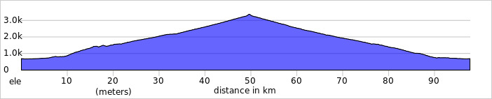
4. (EUROPEAN HIGHEST ROAD) Granada – Monachil – Pradollano – VELETA PEAK – Pradollano – Granada
Distance: 98 KM
Elevation Gained: 2.800 M
Pit Stops: Monachil, Pradollano, Hoya de la Mora, Cenes de la Vega.
The BEST ONE – BIGGEST ONE.
Climb to the highest point in Europe, mighty Veleta Peak with any 3.300 m.a.s. Maybe last meters will be walked.
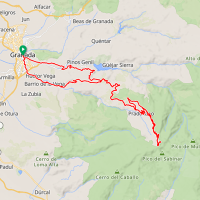
Start must be in Granada where the peak is shining above all heads. It´s bit tricky to find the way to Monachil, but most local cyclist grab same direction. Once you ride under the highway keep along Huétor Vega to Monachil where the climb truly starts. The first section end up in summit called Collado del Muerto (1.488 m.a.s.), a strong 10 KM with slopes over 15%. Comes short flat part before you hit main road to the peak.
Since that crossroad it´s up only for 30 KM. When reaching car-park Hoya de la Mora (2.500 m.a.s.), the road is not aloud for cars anymore and something over 10 KM is left. The altitude and reduced oxygen in air make it harder. Reaching 3.000 elevation even the surface is getting worse as a consequence of weather conditions. Last KM´s are always hard and asphalt is rough but it worth finish it! Believe!
The descent is fast, chilly even in the summer as in the upper slopes the temperature 5 degrees is common during the summer day. Remember to get refreshment during the descent to enjoy high altitude atmosphere.
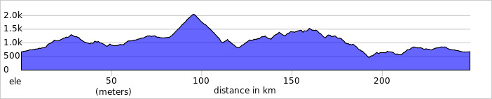
5. (AROUND SIERRA NEVADA) – Granada – Guadix – LA RAGUA – Laroles – Trevélez – Órgiva -Granada
Distance: 248 KM
Elevation Gained: 4.600 M
Pit Stops: Peza, Purullena, Guadix, La Calahorra, Laroles, Bérchules, Pitres, Pórtugos, Busquístar, Pampaneira, Trevélez, Órgiva, Lanjarón.
It´s HIGHLIGHT, it´s SELF-Challenge to ride around this impressive massif.
For those really WELL-TRAINED.
Takes ONE whole day – but stays in mind REST OF LIFE.
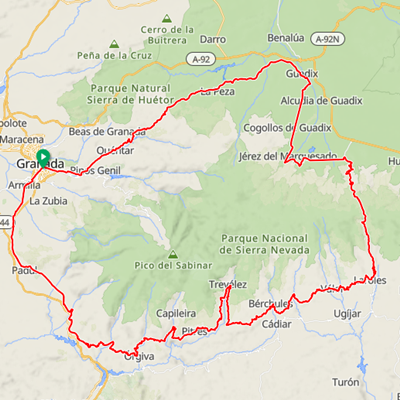
This LIFE CHALLENGE ride starts in Granada or somewhere, depending on the accommodation. First section to Guadix is mild climb to pass Puerto de los Blancares (1.297 m.a.s.), lovely ride between amazing forests. Then the route is descending almost to Guadix with some small climbs.
The northern part of Sierra Nevada is plateau around 1.000 m.a.s with nice views over massif. In Guadix turn right for Jerez del Marquesado and in the town take left direction La Calahorra. There is a perfect spot for meal in Hospedería El Zenete hotel. For those dividing the loop in more days, this place is highly suitable.
From La Calahorra the turn right must be taken as route is heading to the highest point, pass La Ragua (2.041 m.a.s.). Nice climb 14 KM long with gentle grade. The descent to Laroles is long, fast and can be tricky in lower part due to snaky road.
Once you reach Laroles, famous region Las Alpujarras will keep you company for many KM. Undulated road through all villages has its highest point in the highest village of Spain, the center of exceptional Serrano Ham – Trevélez. Since Trevélez you will descent until city of Órgiva. Coming to Órgiva on the roundabout turn right direction Lanjarón, a famous spa town with plenty of possible accommodation.
Leaving Lanjarón the route approaches to highway Motril-Granada so ride on old side road N-323a which brings you directly to Granada.